Refreshing the Upper Billabong is part of the Refreshing Rivers project, a collaboration between government, industry, research and community organisations, led by Murray Local Land Services. This project has been assisted by the New South Wales Government through its Environmental Trust.
HLN & Refreshing Rivers have a Refreshing Rivers – Upper Billabong project running on iNaturalist Australia. You can help us by getting an iNaturalist account (if you don’t already have one), downloading the iNaturalist Australia app, joining the project, and uploading your flora and fauna sightings!
HLN & Refreshing Rivers will also be participating in the Great Southern BioBlitz 2026 in November this year. More details on how you can join our project on iNaturalist will be released shortly.
Southern Pygmy Perch and farm dam water health
Southern Pygmy Perch were formerly found in the Murray and lower Murrumbidgee River systems. There have been large-scale reductions in their range since European settlement, particularly inland. In NSW they are listed as a Threatened Species, but we are excited that populations of Southern Pygmy Perch have been discovered in the past few years to be living in creeks of our Upper Billabong Region.
Southern Pygmy Perch prefer habitat that includes small systems with a low flow rate and quiet vegetated areas in streams, billabongs, and lakes. They like covered habitats and are not usually found in open water. Unfortunately, many of our waterways lack canopy cover, have increasing numbers of invasive species, lack in-stream debris and have been degraded by stock use. This species also require refuge pools during periods of drought, to ensure that when the water returns to flow, their populations survive.
With wild populations of Southern Pygmy Perch fluctuating due to drought conditions, there are several ways for landholders to improve the streams to provide habitat for this species and other fish, including:
Restrict livestock access to streams
Enhance on-farm dams to act as refuge locations
Complete stream restoration, including the addition of instream debris and vegetation
Bank recovery efforts including management of riparian vegetation and removal of willows.
Check out the Refreshing Rivers SPP guide to enhancing farm dams and protecting waterways here.
Water quality monitoring
We conduct water monitoring within the Upper Billabong catchment, each quarter. Monitoring water quality helps us get a picture of the overall health of the creeks and waterways allowing us to notice changes over time. Some of the water quality components that we are measuring include:
1. pH levels – How acidic the water is. Although pH levels vary from place to place, season to season, most plants and animals need a specific pH balance to survive. Some species are extremely sensitive to changes and even a small or sudden change in pH levels can cause harm (a change in pH can also alert us to changes affecting the river, like salt being introduced upstream).
2. Dissolved oxygen (DO) levels – dissolved oxygen in the water is crucial for aquatic life and can indicate water quality.
3. Temperature – How hot or cold the water is. Water temperature is crucial as it influences other properties like salinity, pH, and dissolved oxygen. Substantial changes in temperature can compromise the balance and be disastrous for the waterway.
4. Turbidity – How cloudy the water is. Turbidity measures the number of particles floating in the water. High turbidity (lots of particles) can make the water cloudy, blocking out sunlight which is important for plants and animals to survive. High turbidity can also make it harder for plants to remove pollutants from the water.
5. Salinity – How salty the water is. Drought and certain land management practices can lead to high salinity. Although many plants and animals tolerate salt, most cannot survive excessively high levels. High salinity can cause erosion, a shortage of clean water, and permanent, wide-spread damage to the ecosystem.
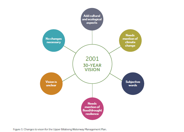
Vision – what the community survey in 2022 found
The Waterway Management Plan uses information on the community’s vision for the catchment, what they value, and threats to those values, to develop targeted management actions. Information on the vision, values and threats in the region were collated using the community survey, in-person discussions, site visits, input from Holbrook Landcare Network and a review of legislation, literature and other data. In the survey, respondents were presented with the vision developed as part of the Upper Billabong Land and Water Management Plan in 2001: “To improve the economic, social and physical environment of the Upper Billabong Catchment by the implementation of a viable Land and Water Management Plan through education, participation and community ownership” (Upper Billabong Land and Water Management Plan, 2001).
Respondents were asked:
Is there anything you would change about this vision, for the refreshed Waterway Management Plan?
Responses are summarised in Figure 1 below:
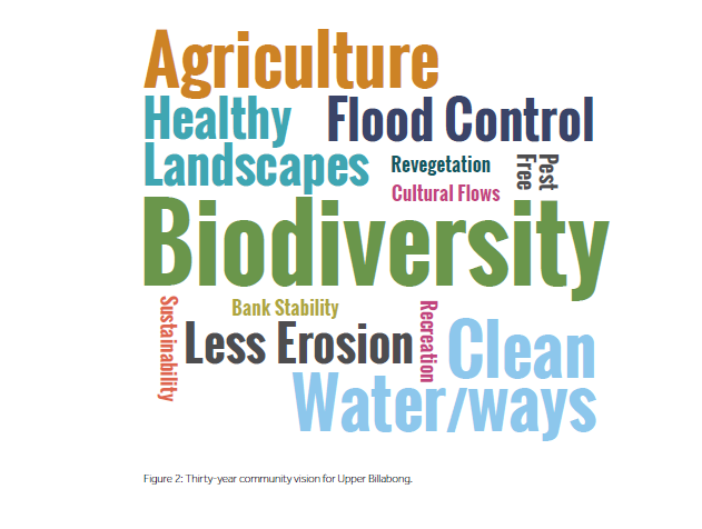
Respondents were also asked:
How would you like the Upper Billabong catchment to be, feel or look in 30 years’ time?
Topics such as biodiversity, clean water and waterways, agriculture, healthy landscapes, flood control and less erosion featured heavily in the text responses. See the word cloud in Figure 2 below.
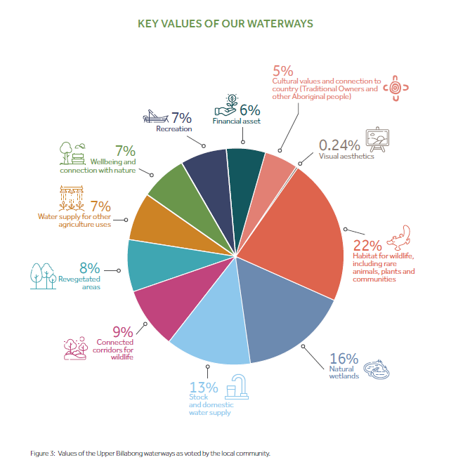
Values
In the survey, 12 values were listed, and respondents were asked to rank these values in terms of their importance . The survey results are summarised in Figure 3 below. The plan has taken the values identifed by the community and set out objectives to ensure the assets are protected and enhanced for the future.
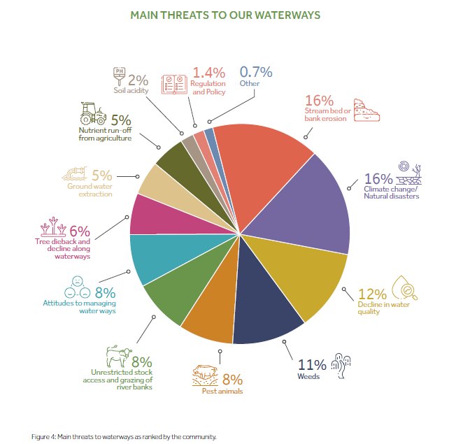
Threats
In the survey, 13 values were listed, and respondents were asked to rank these values in terms of their importance.
The survey results are summarised in Figure 4 below.
Click here to view previous community survey findings and data